
You finally made it to Houston to pursue your graduate studies. You were advised to get yourself a car to shorten the city’s gargantuan distances. Now you are looking for a way to make full use of it. Maybe you were hardworking (and lucky) enough to be hired for an internship in California, or maybe you are just overdue for a good old American road trip. If the thought of 2000 miles separating Houston to the Golden State seems like an insurmountable barrier to your dreams, don’t panic: I got you covered. Whoever you are, this is a guide for your next memorable road trip.
My name is Gaetano, and I am a Ph.D. candidate in the Earth, Environmental and Planetary Sciences department at Rice University. In late Spring 2025 I finalized my decision to spend one month in the upcoming summer doing research as a visiting scholar at the United States Geological Survey (USGS in short), at their Mountain View location in the Silicon Valley. When I was presented with the choice between taking a plane and driving my newly bought used Mazda3, I had no doubt in my mind: as an international student, a long road trip through the Southwestern United States had long been an inaccessible dream of mine.
Before we get started, here are a few general notes:
Preparation This trip is going to be hard on you and your car, so make sure you are prepared. Regardless of how new and reliable your car is, it’s always better to be safe than sorry. I recommend taking your car to a mechanic for a thorough check-up. Change the oil and the filters, check the brakes, air conditioning, windshield wipers and,importantly, the tires. In my case, this was a great time to buy new tires. While not a cheap purchase, it was a necessary one.
Despite how much time and effort you dedicate to preparing your car for the trip, you cannot predict the unexpected, such as your car giving up on you in the middle of the highway or ending up with a flat tire. You can, however, predict solutions to such problems. While most insurance plans and credit cards cover basic roadside assistance necessities, I strongly recommend starting a AAA (American Automobile Association) membership for a long road trip like this. For example, the Plus plan will entitle you to free towing up to 100 miles, emergency fuel delivery and multiple other amenities for just 10 USD per month. In my opinion, this is a very small price for one’s peace of mind.
Lodging There are going to be plenty of lodging options along the way. While some people may prefer to camp or sleep in their car, I believe that a good night of sleep is fundamental to undertake the long drive that’s ahead of you the day after, so I ultimately decided on a good old-fashioned bed. As far as my experience goes, Motels and Inns offer the best value for money, provided that you carefully check their reviews to make sure that they are safe and clean. For this reason, I got in the habit of planning and booking each night’s stay the night before, rather than stopping at the first neon sign I saw along the road. This also forced me to stick to my plans and maintain a solid driving schedule each day, which allowed me to save some time each evening to have a good dinner in a local restaurant or explore the places I was stopping in.
Routes Several roads lead to California, but some are prettier than others. In this guide, I will describe two possible routes to go from Houston to the Bay Area and back, based on an attempt to optimize travel time and maximize sightseeing.What’s the point of a road trip if it doesn’t take you through beautiful places? While the general itinerary will be fairly straightforward and easy to remember, I strongly suggest gathering some physical maps in advance of your trip, in case something happens like your phone dies or you do not have service. Personally, I bought a Rand McNally large format 2026 Road Atlas to keep in the back of my car on the off chance my phone didn’t have service when I needed it to. At the beginning of each driving day, check your itinerary and make sure to know where you’re going. In other words: don’t follow your navigation system blindly.
Gas Always (really, always!) make sure to have enough fuel to make it to the next gas station. You are going to traverse lots of deserted (literally, in the desert) areas, and while your AAA membership will have you covered in case you ran out of gas, you don’t want that to happen, especially if you are driving alone. So, when in doubt, just gas up and thank yourself (and me) later. Speaking of gas, keep in mind that prices will get increasingly higher as you leave Houston, from a minimum of 2.73 USD per gallon in the Space City to an average of 4.5 USD in California.
Without further ado, here is the account of my Great American Road Trip.
Day 1
You’ll probably hear this from every single soul in the Lone Star State: driving through West Texas along Interstate 10 is as boring as driving gets. At least, it’s simple, and it’ll take you all the way to California without the need to worry about any other road. I began my journey from Houston on August 14, at 4:30 A.M. Why so early? Several reasons: less traffic, cool weather, and more time to make up for possible inconveniences along the way. The goal for the first day was to leave Texas and spend the night in Las Cruces, NM, 50 miles north of El Paso. Speaking of inconveniences, I had not predicted to get stuck for almost 2 hours in a gas station near Kerrville, TX, some 70 miles northwest of San Antonio, due to one of the flash floods that have been ravaging the Hill Country. I wish I could make up stories to sugarcoat how boring and uneventful this first day of driving was, but the truth is that I am not good at lying. The road to El Paso was a never-ending unfolding of the same landscape, like listening to an instrumental song on repeat. Things got way more interesting as I drove through El Paso, where some stretches of Interstate 10 represent the almost exact border between the US and the Mexican city of Ciudad Juarez. It was hard not to be fascinated by the drastic change in scenery, colors and architecture unfolding across the highway. One hour later, I eventually made it to Las Cruces, where I spent the night at a Days Inn motel after having dinner at Blake’s Lotaburger, New Mexico’s classic burger chain.
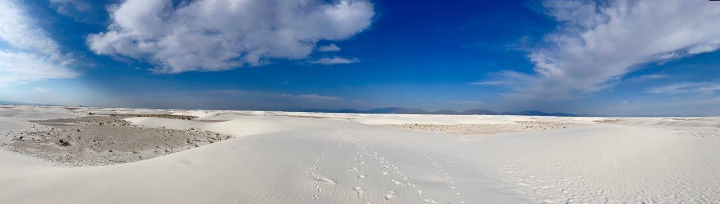
Expanse of gypsum sand at White Sands National Park (New Mexico)
Day 2
This is when things started to get interesting. After a long night of sleep to recover from my aching and overused back, I hopped on US Highway 70 and crossed the San Augustin Pass between the San Andres and Organ Mountains of New Mexico, headed to White Sands National Park, only a 50-minute drive from Las Cruces. After descending into the Tularosa Basin and crossing a Customs and Border Protection checkpoint, I finally made it to the park and recharged my driving batteries with a long walk on the pale gypsum sand under the faint early morning sun. Half-an hour later, I was ready to go, jumped in my now dusty Mazda3 and headed West on I-10 towards Tucson, AZ. Five hours of nearly non-stop driving took me to the eastern visitor center of Saguaro National Park, at the foot of the Rincon Mountain. Due to the scorching heat and the high risk of wildfires, I was advised not to hike by the park rangers, and drove instead along Cactus Forest Drive, a scenic 8-mile loop that took me through gentle hills blanketed by the park’s iconic cactus forest and offered me a condensed experience of the diverse Sonoran Desert flora. Due to an incoming storm, I quickly rushed to Phoenix, where I spent the night in a SureStay Inn. Not before feeding myself another burger, this time at the ‘50s themed Nana Dee’s diner.
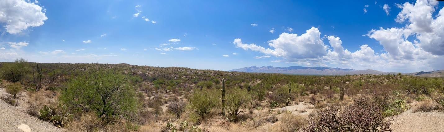
View of Saguaro National Park(Arizona) from cactus Forest Drive

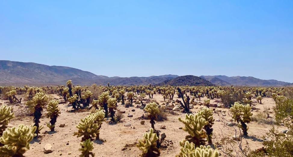
Cholla Cactus Forest in Joshua Tree National Park (California)
Day 4
This was the last day of the first half of the trip, and my last time on I-10. As I turned northwest on Interstate 5 just outside Los Angeles, I got caught in multiple accidents along the way and instantly regretted the fluidity of I-10. After crossing the Tejon Pass through the Tehachapi Mountains, the scenery changed dramatically. To the left, the base of the Southern Coast Ranges. To the right, the endless expanse of the Central Valley, with its orchards and vineyards. The almost 200 miles between the Tejon Pass Pacheco Pass, which takes you West through the Diablo Range was monotonous but pleasing to the eye, while the descent to the town of Gilroy was pleasing to the nose, with the strong scent of the garlic capital of the world quickly making its way into my car. From there, it was only one more hour of driving before I made it to Sunnyvale, where I spent the following month. There is so much I could talk about the following month: the cypress groves of Point Lobos, the high peaks of Pinnacles, the fog and winds of Point Reyes, the grandeur of Yosemite and the gravity of Big Sur, but that’s another story. For the time being, I will fast forward one month and tell you about my road trip back to Houston.
Back to Houston
Day 1
For the first day of travel, I had initially planned to drive from the Silicon Valley to Las Vegas through Yosemite and the Owens Valley, since this is the most scenic route connecting the two locations. However, my car had started showing signs of distress when driving uphill, so I opted instead for the fastest and flattest route, that is going southeast along Interstate 5 through California's Central Valley, then northeast on California State Route 178 through the edge of the Basin and Range province. This itinerary took me through Death Valley National Park, which is the last place in the United States you’d want to visit in mid-August due to the scorching dry heat and the absence of any cover whatsoever. It was impressive nonetheless, and I got to drive down to Badwater Basin, the lowest point of the continental U.S. at 282 feet below sea level and admire an otherworldly view from Zabriskie Point. From there I headed to Las Vegas, where I stayed for the night.
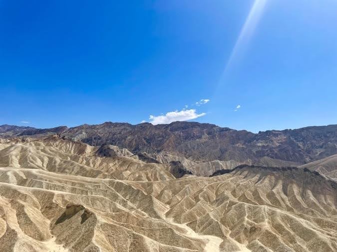
View from Zabriskie Point in Death Valley National Park (California)
Day 2
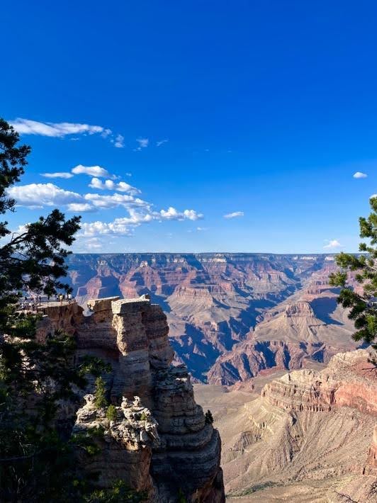
For those who can look past its reputation as Sin City, Las Vegas is surrounded by impressive geology. On the morning of the second day, I shortly detoured west of the city to admire the towering sandstones of Red Rock Canyon, then I headed east on Interstate 40 towards the South Rim of Grand Canyon National Park. After almost 5 hours of driving, I could finally marvel at the geological wonder carved by the Colorado River from the scenic view of Mather Point. I really wish I had time for a short hike, but the day was coming to an end, and I had to reach my next stop, so I hopped back on I-40 and followed the Old U.S. Route 66 to the small town of Holbrook, where I spent the night in a Motel 6.
View from Mather Point, Grand Canyon National Park (Arizona)
Day 3
The town of Holbrook is right at the edge of another National Park, Petrified Forest, where fossils of some of the earliest dinosaurs are constantly dug from the colorful rocks of the Chinle Formation, deposited some 220 million years ago. Here, I spent more time than I had planned driving through the badlands of the Painted Desert and counting the logs of petrified wood that I encountered along the way. Then, I hit the road again for a full day of driving from Arizona to Texas, passing through beautiful New Mexico. There I managed to make two impromptu stops at El Morro and El Malpais National Monuments, where I enjoyed a scenic view of the lava flows associated with the Zuni-Bandera volcanic field: I am a volcanologist after all. A long stretch of wind turbines welcomed me across the Texas border, where I spent the night at the Bonanza Motel in the small town of Vega, half an hour west of Amarillo.
Day 4
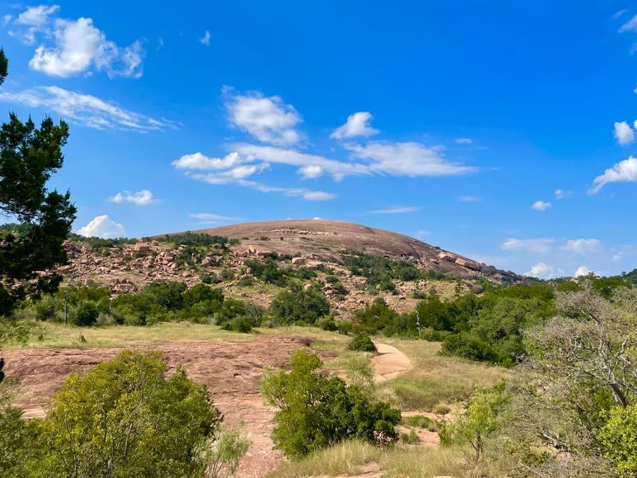
This was the last day of the road trip, and the one in which I forgot to adjust my watch for the changing time zone and ended up waking up two hours later than scheduled… After rushing out of Vega, I headed south of Amarillo on Interstate 27, then southeast on U.S. highway 84 towards Llano. The original plan included a quick stop at Palo Duro Canyon State Park, the second largest canyon of the United States after the Grand Canyon, but I had to forgo that because of the unexpected delay. Instead, after 7 hours of driving I decided to stop at Enchanted Rock, a massive 1 billion-year-old granite dome near Llano, and reactivated my wasted muscles by hiking to the summit and back. This took one hour in total, and by the end of the hike I was ready to resume my trip back to Houston. Before heading back home, however, there was one last stop that I needed to do: after one month away from home, I was in desperate need of some good Texas BBQ. Luckily, Southside Market in Elgin was just halfway between Llano and Houston, and it provided me a well deserved treat in the form of a delicious brisket sandwich. Two hours later I was in my bed in Houston, the final stop to my Great American Road Trip and the one that I currently call home.
View of the granite dome of Enchanted Rock State Natural Area (Texas)
About the author:
Gaetano Ferrante is a Ph.D. candidate in the Earth, Environmental and Planetary Sciences Department at Rice, where I work on numerical models and experiments to better understand volcanic eruptions. He comes from a very small village near Napoli, Italy, which you may know for the best pizza in the world or for their football club, depending on your priorities. Read more
Further reading